


Grand Teton Mountaineer’s Map
Price range: $35 through $330
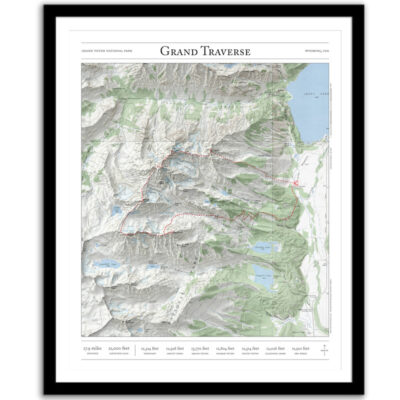
Bring the wilderness home with this print of the major routes to the summit of the Grand Teton. This mountaineering map combines hillshading, detailed topography, and route info to tell the story of your time in Wyoming. Made by an independent artist.
For illustrative use only. Not for navigation.
About the Grand Teton
At 13,775 feet tall, Grand Teton is the highest mountain in Grand Teton National Park in Northwest Wyoming. Routes that appear on the map:
- Owen-Spalding
- Upper Exum Ridge
- Lower Exum Ridge
- Direct Petzoldt Ridge
- Ford-Stettner (Ski Descent)
- East Ridge
- North Face
- North Ridge
- Black Ice Couloir
I hope my wall art brings you closer to one of your favorite places. It’s a perfect gift for mountaineering and climbing partners, friends, and family members who love Wyoming and Grand Teton National Park.
Text and/or cropping might vary slightly at different map sizes. Please view the photos above to see the exact content on the 11×14, 16×20, and 22×28 maps.
Josh did an amazing job customizing a Mt Rainier map for me to give to a friend. The print and frame are professionally packaged and high quality My friend loved the print. Josh is responsive, patient and so easy to work with. I will definitely order from Paper Cairns again!
Beautiful quality every time. I’ll be buying more for myself and as gifts.
Map is beautiful – I love that our wonderland trail route is marked as with a lot of landmarks we visited along the way. My son will love it when he gets it for his birthday! Thank you!