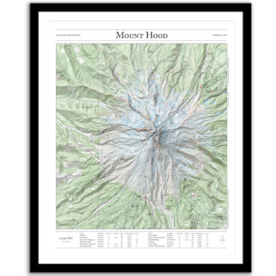
Timberline Trail
$55 – $330Price range: $55 through $330
Bring the wilderness home with this print of the Timberline Trail around Oregon’s Mount Hood. This trail map combines hillshading, detailed topography, and route info to tell the story of your time on the mountain. Made by an independent artist.
For illustrative use only. Not for navigation.
About the Timberline Trail
The Timberline loop circumnavigates Mount Hood (elevation 11,240 feet). It passes through evergreen forests, alpine meadows, and barren lava flows; crosses several rivers; and provides abundant views of waterfalls, glaciers, and peaks.
- 40 miles
- 9,500 feet of elevation gain
Text and/or cropping might vary slightly at different map sizes. Please view the photos above to see the exact content on the 11×14, 16×20, and 22×28 maps.
| 5 star | 100 | 100% |
| 4 star | 0% | |
| 3 star | 0% | |
| 2 star | 0% | |
| 1 star | 0% |
Sorry, no reviews match your current selections
Small maps – 11″ x 14″
- Poster paper (unframed)
- Fine art giclee print (unframed)
- Framed fine art giclee print
Medium maps – 16″ x 20″
- Poster paper (unframed)
- Fine art giclee print (unframed)
- Framed fine art giclee print – Shown in the lifestyle photo. Model is 5' 9" tall.
Large Maps – 22″ x 28″
- Poster paper (unframed)
- Fine art giclee print (unframed)
- Framed fine art giclee print
Paper
- Poster Paper — classic poster paper with a satin finish, bright white point, and vivid color.
- Giclée — acid-free archival-grade ink, acid-free 100% cotton, single-side coated paper. Has a matte surface.
Frames (Giclee only)
- Black Frame — ¾” wide, wood with veneer
- Walnut Fame — 1 1/4” wide, wood
- Maple Frame — 1 1/4” wide, wood
- Matting — 1” wide, conservation-grade (white)
Production Time
- Average printing/production time for paper only (poster or giclee) is 3–5 business days.
- Average printing/production time for paper and a frame is 5–8 business days.
Shipping Time
- Unframed prints ship via USPS (3–6 business days).
- Framed prints ship via UPS or FedEx (3–6 business days).
- International shipping is not available at this time.
Returns and Refunds
- Do you accepts returns or give refunds?
Because I print each map specifically for each order, I’m not able to accept returns or offer refunds. - If your item was damaged during shipping, please let me know and I’ll work with my printing partner to send you replacement copy.
Process
I use precise digital elevation models (DEMs) to create shaded relief for every valley, ridge, peak, and river, which I add to vintage 1:24,000 topo maps from the United States Geological Survey. These historic maps were originally printed on a lithographic press and field-checked on foot, and they give each print a natural, authentic feel.
Commission a Personal Map
If I don't have a map for a trail or place you love, you can commission a personal map. You can also vote for the next map.
Legal Disclaimer
My maps are for illustrative purposes only. Although almost all the natural features are accurate, historic USGS maps are of varying age, reliability, and resolution, glaciers and routes above treeline change frequently. These prints should not be used for navigation, land ownership claims, or up-to-date information about public access.


We are very pleased with our purchase. The map is beautifully framed and top quality print. It’s a unique gift that was a meaningful memory- our favorite family hike. We purchased it for our 15 year old and he loves it. I will definitely buy from here again!
Beautiful map of a memorable backpack – love it and will definitely be purchasing others.
An amazing map with exactly the right data and art work. Nothing else like this exists. Completely unique.