Rim to Rim to Rim (R2R2R)
$35 – $330
Bring the wilderness home with this print of the trail running / hiking route from the Grand Canyon’s South Rim to the North Rim and back. Available in three variations depending on your trailhead. This trail map combines hillshading, detailed topography, and route info to tell the story of your time in Arizona. Made by an independent artist.
For illustrative use only. Not for navigation.
About R2R2R
Descend to the bottom of the canyon, cross the Colorado River and travel through the hottest part of the canyon (“The Box”), ascend to the top of the opposite rim, and return. The route features demanding terrain, drastic elevation change, and significant temperature variation.
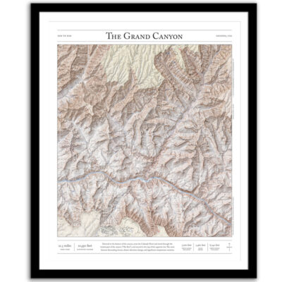
South Kaibab to North Kaibab to South Kaibab route
- Distance (round-trip): 42.6 miles
- Elevation change: 21,100 feet
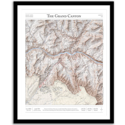
Bright Angel to North Kaibab to Bright Angel route
- Distance (round-trip): 47.8 miles
- Elevation change: 20,300 feet
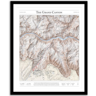
South Kaibab to North Kaibab to Bright Angel route
- Distance (round-trip): 45.2 miles
- Elevation change: 20,700 feet
I hope my wall art brings you closer to one of your favorite places. It’s a perfect gift for running/hiking partners, friends, and family members who love the outdoors and the Grand Canyon.
Text and/or cropping might vary slightly at different map sizes. Please view the photos above to see the exact content on the 11×14, 16×20, and 22×28 maps.
5 star | 100 | 100% |
4 star | 0% | |
3 star | 0% | |
2 star | 0% | |
1 star | 0% |
Customer Images
Michael Smith
Very nice work. The map I ordered is the largest Wonderland map Paper Cairns offers and the printing is very clear and easy to make out all the little details . I ordered the maple frame. It has very clean miter cuts. I used hard locking mounts for my installation but the frame does come with mount points on the sides near the top. They look very solid and should provide for a solid installation. The shipping was quick. It showed up by FedEx within a couple days and it was well protected. Highly recommended for those that want a display quality contour map of Mount Rainer.
Alex D.
Fun and Great Memories! Working with Josh was a truly enjoyable experience - he has a true love for the mountains and understood how to build a beautiful and narrative description that captured the essence of our exciting trip to the summit of Mount Adams.
Alex D.
Fun and Great Memories! Working with Josh was a truly enjoyable experience - he has a true love for the mountains and understood how to build a beautiful and narrative description that captured the essence of our exciting trip to the summit of Mount Adams.
Alex D.
Fun and Great Memories! Working with Josh was a truly enjoyable experience - he has a true love for the mountains and understood how to build a beautiful and narrative description that captured the essence of our exciting trip to the summit of Mount Adams.
Dave McBride
In Fall of 2021, my wife and I ran a R2R2R. We're old and slow, so it took us 25 hours, but we loved every minute of it. Thanks for such a wonderful product to help us remember our trip. We often look at the route and say, "Remember, this is where we...." The quality is great, the information around the outside is fantastic, and the red line showing the trail makes this map unique. A great souvenir!
Michelle M.
Fantastic show piece to go along with all our other memories.
Kevin S.
I hiked this route, south to north, in September 2013. Great quality map. I love the small details; elevation at north and south rim, total miles, etc. A wonderful way to memorialize what was an amazing experience.
Kevin S.
I hiked this route, south to north, in September 2013. Great quality map. I love the small details; elevation at north and south rim, total miles, etc. A wonderful way to memorialize what was an amazing experience.
Kevin S.
I hiked this route, south to north, in September 2013. Great quality map. I love the small details; elevation at north and south rim, total miles, etc. A wonderful way to memorialize what was an amazing experience.
Kevin S.
I hiked this route, south to north, in September 2013. Great quality map. I love the small details; elevation at north and south rim, total miles, etc. A wonderful way to memorialize what was an amazing experience.
Kevin S.
I hiked this route, south to north, in September 2013. Great quality map. I love the small details; elevation at north and south rim, total miles, etc. A wonderful way to memorialize what was an amazing experience.
Sorry, no reviews match your current selections
Small maps – 11″ x 14″
- Poster paper (unframed)
- Fine art giclee print (unframed)
- Framed fine art giclee print
Medium maps – 16″ x 20″
- Poster paper (unframed)
- Fine art giclee print (unframed)
- Framed fine art giclee print – Shown in the lifestyle photo. Model is 5' 9" tall.
Large Maps – 22″ x 28″
- Poster paper (unframed)
- Fine art giclee print (unframed)
- Framed fine art giclee print
Paper
- Poster Paper — classic poster paper with a satin finish, bright white point, and vivid color.
- Giclée — acid-free archival-grade ink, acid-free 100% cotton, single-side coated paper. Has a matte surface.
Frames (Giclee only)
- Black Frame — ¾” wide, wood with veneer
- Walnut Fame — 1 1/4” wide, wood
- Maple Frame — 1 1/4” wide, wood
- Matting — 1” wide, conservation-grade (white)
Production Time
- Average printing/production time for paper only (poster or giclee) is 3–5 business days.
- Average printing/production time for paper and a frame is 5–8 business days.
Shipping Time
- Unframed prints ship via USPS (3–6 business days).
- Framed prints ship via UPS (3–6 business days).
- International shipping is not available at this time.
Returns and Refunds
- Do you accepts returns or give refunds?
Because I print each map specifically for each order, I’m not able to accept returns or offer refunds. - If your item was damaged during shipping, please let me know and I’ll work with my printing partner to send you replacement copy.
Process
I use precise digital elevation models (DEMs) to create shaded relief for every valley, ridge, peak, and river, which I add to vintage 1:24,000 topo maps from the United States Geological Survey. These historic maps were originally printed on a lithographic press and field-checked on foot, and they give each print a natural, authentic feel.
Commission a Personal Map
If I don't have a map for a trail or place you love, you can commission a personal map. You can also vote for the next map.
Legal Disclaimer
My maps are for illustrative purposes only. Although almost all the natural features are accurate, historic USGS maps are of varying age, reliability, and resolution, glaciers and routes above treeline change frequently. These prints should not be used for navigation, land ownership claims, or up-to-date information about public access.
I absolutely love the Wonderland Trail map print! It’s beautifully detailed and captures the essence of one of my favorite hiking experiences. I completed the Wonderland Trail on a memorable 10-day journey, and this map brings back all the amazing memories—stunning vistas, challenging climbs, and the sense of accomplishment at the end. The quality of the print is exceptional, and it’s a perfect addition to my home. Thank you for creating such a thoughtful piece that celebrates this incredible place! Highly recommend for anyone who loves the outdoors or has a special connection to the Wonderland Trail.
Fantastic, well crafted way to memorialize one of the greatest memories of my life!
My second map! Very high quality!
beautiful, good quality
Great experience designing a custom map and the results were outstanding!