


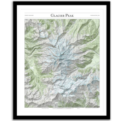
Glacier Peak: Mountaineer’s Map
Price range: $35 through $330
Bring the wilderness home with this print of Glacier Peak and the mountaineering route to the summit. This trail map combines hillshading, detailed topography, and route info to tell the story of your time on the mountain. Made by an independent artist.
For illustrative use only. Not for navigation.
About Glacier Peak
A well-maintained trail through an old-growth red cedar forest joins the PCT near White Pass. A climber’s path continues to the summit, crossing alpine meadows, Gerdine and Cool Glaciers, and pumice fields.
- 10,541′ high
- 32.9 miles round-trip
- 8,180′ of elevation gain.
Routes above treeline change often depending on snow conditions. Do not use this map for navigation.
Text and/or cropping might vary slightly at different map sizes. Please view the photos above to see the exact content on the 11×14, 16×20, and 22×28 maps.
We are very pleased with our purchase. The map is beautifully framed and top quality print. It’s a unique gift that was a meaningful memory- our favorite family hike. We purchased it for our 15 year old and he loves it. I will definitely buy from here again!
Beautiful map of a memorable backpack – love it and will definitely be purchasing others.
An amazing map with exactly the right data and art work. Nothing else like this exists. Completely unique.