


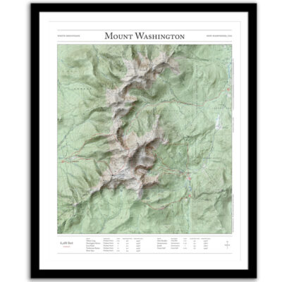
Presidential Traverse
Price range: $55 through $330
Bring the wilderness home with this print of the Presidential Traverse in New Hampshire’s White Mountains. This trail map combines hillshading, detailed topography, and route info to tell the story of your time in the mountains. Made by an independent artist.
For illustrative use only. Not for navigation.
Variations that appear on the map
- Air Line – Appalachia trailhead
- Valley Trail – Appalachia trailhead
- Pine Link – Pine Mountain trailhead
- Daniel Webster – Dolly Copp campground
- Crawford Path – Highland Center
- Webster-Jackson – Webster-Jackson trailhead
Summits that appear on the map
- Mt. Madison – 5,366 feet
- Mt. Adams – 5,774 feet
- Mt. Jefferson – 5,712 feet
- Mt. Clay – 5,531 feet
- Mt. Washington – 6,288 feet
- Mt. Monroe – 5,374 feet
- Mt. Franklin – 4,904 feet
- Mt. Eisenhower – 4,760 feet
- Mt. Pierce – 4,312 feet
- Mt. Jackson – 4,052 feet
- Mt. Webster – 3,911 feet
Text and/or cropping might vary slightly at different map sizes. Please view the photos above to see the exact content on the 11×14, 16×20, and 22×28 maps.
Josh did an amazing job customizing a Mt Rainier map for me to give to a friend. The print and frame are professionally packaged and high quality My friend loved the print. Josh is responsive, patient and so easy to work with. I will definitely order from Paper Cairns again!
Beautiful quality every time. I’ll be buying more for myself and as gifts.
Map is beautiful – I love that our wonderland trail route is marked as with a lot of landmarks we visited along the way. My son will love it when he gets it for his birthday! Thank you!