


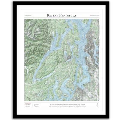
Kitsap County
Price range: $35 through $330
Bring the Pacific Northwest home with this print of Kitsap County and the Puget Sound. This map combines hillshading and detailed topography to tell the story of western Washington. Made by an independent artist.
For illustrative use only. Not for navigation.
About Kitsap County
Although one of the state’s smallest counties, Kitsap County ranks third in population density. It was established in 1857 as Slaughter County, but renamed several weeks later in honor of a local Suquamish chief.
- High point: 1,761 feet (Gold Mountain)
- Land area: 395 sq miles
- Saltwater shoreline: 228 miles
Text and/or cropping might vary slightly at different map sizes. Please view the photos above to see the exact content on the 11×14, 16×20, and 22×28 maps.
We are very pleased with our purchase. The map is beautifully framed and top quality print. It’s a unique gift that was a meaningful memory- our favorite family hike. We purchased it for our 15 year old and he loves it. I will definitely buy from here again!
Beautiful map of a memorable backpack – love it and will definitely be purchasing others.
An amazing map with exactly the right data and art work. Nothing else like this exists. Completely unique.